Buss to Hike: Hiking at Trollstigen


Åndalsnes - Trollstigen - Åndalsnes
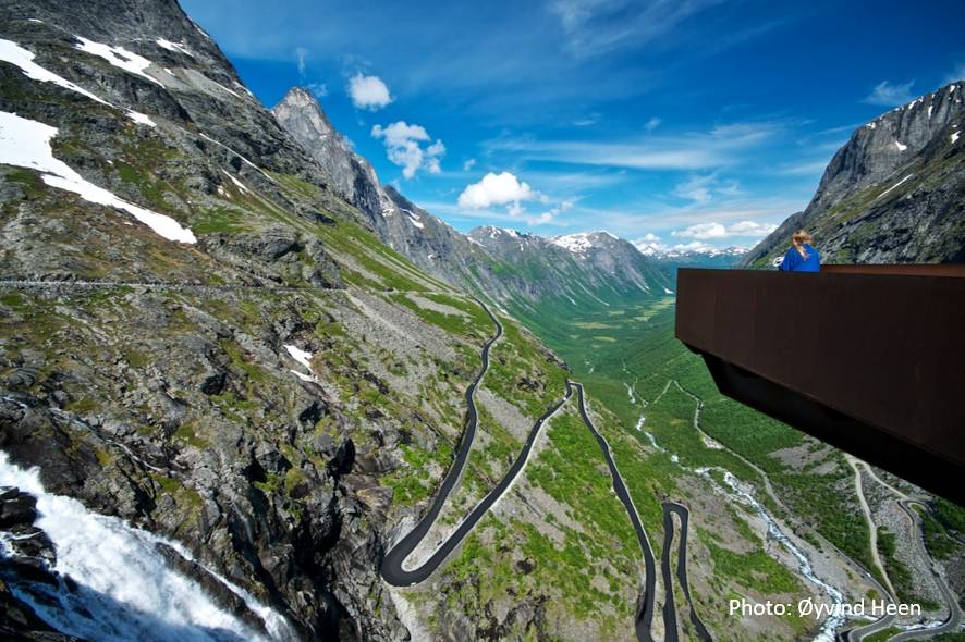
Trollstigen is famous for the road leading up to the Trollstigen plateau. With its many hairpin turns the road curves up the mountain side and on the top you can enjoy a spectacular view from the various viewpoints.
However, the Trollstigen plateau is also a great starting point for very nice hikes and on this round trip you will have enough time to enjoy the views from the Trollstigen plateau and also go on a hike. We recommend either the Bispevatnet lake or Alnessteinen (the Alnes Rock).
Note! The hikes are not guided. You must ensure that you have enough information about the hike before starting and bring everything you need to make sure you have a good hike.
Suggested hike 1: Bispevatnet lake
Difficulty: medium (suitable for anyone in good shape who are used to follow a marked path)
Duration: approx. 1 hour each way (a total of 2 hours active walking to go there and back)
The hike starts just across from the Trollstigen plateau, by a bridge over the river or just after the bridge. Follow the road 30 m upwards and cross the road. The start of the path is marked with a red T. Follow the ridge upwards until the terrain becomes flatter and you can see a little pond.
Turn right around a protruding rock and then continue upwards along a route marked with cairns. Approx. 100 m after the protruding rock, the path goes right - crossing an area of bare rock, and then upwards through a scree slope. Keep right up another ridge, and then keep right at the next large scree slope. Then the path follows the ridge upwards, slightly turning right. When you reach the lake, you can continue upwards to a picnic area by some big rocks.
Suggested hike 2: Alnessteinen (the Alnes Rock)
Difficulty: medium (suitable for anyone in good shape who are used to follow a marked path)
Duration: approx 1 hour each way (a total of 2 hours active walking to go there and back)
The hike starts approx. 10 minutes by foot from the Trollstigen plateau in the direction of Valldal. Follow the road towards Valldal until you see signs to Alnessteinen on the left side of the road.
From the start, the path goes along the river and then continues towards a lake. After approx. 300 meters, the path can be a little diffuse, but shortly after it becomes easy to see and follow all the way to Alnesvatnet lake.
From the Alnesvatnet lake follow the path that goes along the left side of the Alnes valley. After a short upwards slope you will see a large rock on the right which is a nice picnic spot. This is the Alnes Rock.
When you book this trip, you will receive an e-mail with a ticket that is valid for the whole trip. You will also receive a tour description that contains detailed information about departure times and where you must change to another bus, boat of ferry – when applicable. The tour description also includes some information about the trip and the destination.
For many of the trips there is a free audio guide available that you can download to your mobile phone. The guide displays text, pictures, and audio information about points of interest along the route. The tour description you receive includes more information about downloading the audioguide.
Departure from: Setnes or Åndalsnes railway/bus station
About our trips
This is a “Travel like the locals” tour. The tours use public transport, i.e. regular buses, ferries and boats, but we have done the planning for you so that you can concentrate on enjoying your trip. You travel on your own - there is no guide or tour leader. On most of our tours you must change several times between different buses/ferries/boats, and it is up to you to make sure you catch your connections – truly travelling like a local! The tours are set up so that the buses, ferries and boats connect.
Click here to see our Terms and Conditions.
